Multi-component geophysical survey at the Classical Greek cities of Mantinea and Elis
Introduction
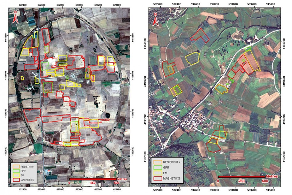
New advances in geophysical survey methods have facilitated the rapid and non-invasive assessment of geographically extensive archaeological sites. We report here on multi-technique investigations used to investigate the classical Greek cities of Elis and Mantinea in the Peloponnese (Figure 1). This work has used magnetometry, electromagnetic induction, ground-penetrating radar (GPR), soil resistivity and high-resolution aerial photography. Multi-sensor magnetometry has been particularly successful for validating, and augmenting, the evidence for road systems previously identified from satellite imagery (Donati & Sarris, in press). These new data have substantially extended the estimated size of Elis and have provided significant details about the urban planning of Mantinea. Using conventional excavation and geophysical methods to map buried features on this landscape scale is impractical; our methodology provides the site coverage necessary, at an acceptable speed, to test hypotheses rigorously about the spatial organisation of ancient Greek cities.
Background to the archaeological sites
The city of Mantinea, located in Arcadia in the north-central Peloponnese, is particularly known for its combative history with Sparta. Most notably, in 385 BC the Mantineanas were forced to abandon their city after the Spartans dammed the Ophis River, causing extensive flooding and allowing the city’s defensive walls to be breached (Xenophon, Hellenica 5.2.1–7; Warner 1979). The city is contained within a fortified ellipse of walls with a circumference of approximately 4km. Archaeological investigations by the French School of Athens (Fougères 1889), and subsequently by the local Ephorate of Prehistoric and Classical Antiquities, have focused on the centre of the site, which contains the agora, various public and religious buildings, and a theatre. Small-scale geophysical survey has previously been undertaken near this area (Sarris 1992: 193–280), but the nature of the archaeological material across the remainder of the site, which is now used for agriculture, is essentially unknown.
The city of Elis is located in the north-west Peloponnese. It is famed for its role as the overseer of the sanctuary of Zeus at Olympia and as the administrator for the Olympic Games (Yalouris 1996). The site was first excavated by the Austrian Archaeological Institute from 1910–1914, with subsequent investigations undertaken by the Austrian Archaeological Institute, the Archaeological Society of Athens and the local Ephorate of Prehistoric and Classical Antiquities (Andreou & Andreou 2007). Archaeological investigations have concentrated mainly in an area within a 600m radius of the central agora. Geophysical investigations undertaken in 2003 confirmed that the city had an extensive, orthogonal road system continuing beyond this area (Tsokas et al. 2012), although due to the absence of an external defensive wall, the boundary of the city is poorly defined. The site where the former city was located is now used for a variety of agricultural purposes and includes the modern town of Kalivia.
Methods
Geophysical data were collected during two field campaigns in 2014. Electromagnetic induction data were collected using a Geophex GEM-2 and a CMD Miniexplorer. Magnetic gradiometer data were collected with a Sensys MX V3 with eight fluxgate sensors. GPR data were collected with a Sensors and Software Noggin-Plus with a 250MHz antenna. Resistivity mapping and tomography data were collected with a Geoscan Research FM85 with a twin probe configuration and an Iris Syscal Pro with 1m electrode spacing respectively. High-resolution aerial imagery was collected to complement the geophysical data using a near infra-red and standard camera mounted on a DJI Phantom 1 and a modified Droidworx CX4. Sub-centimetric positioning data was provided by a suite of Javad Triumph 1 units with HEPOS correction.
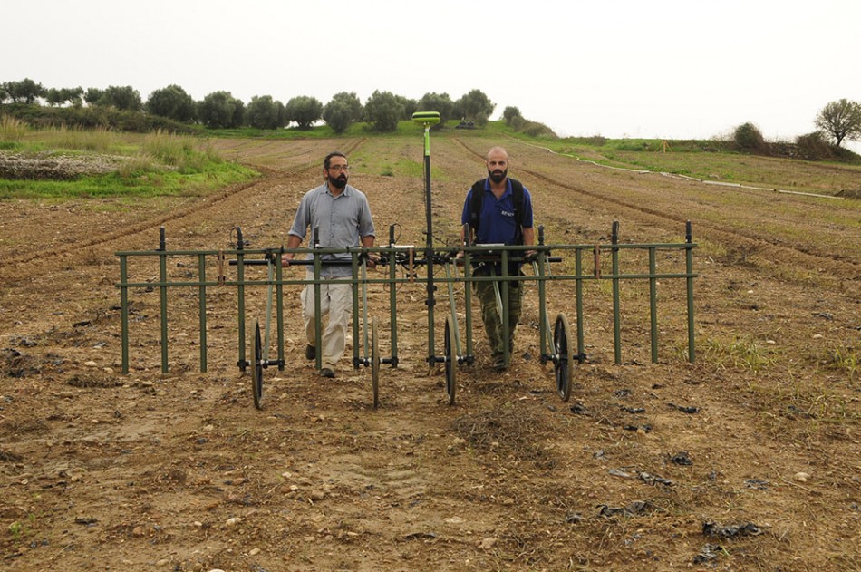
At each site, the survey methodology aimed to cover all areas with suitable ground conditions using the Sensys multi-sensor magnetometer (Figure 2) as a means of mapping the spatial organisation of the road network and to validate previous remotely sensed satellite data. This approach allowed an average of about 2.5ha of ground coverage per day with a 0.5m sensor spacing. This was augmented strategically by the Geophex GEM-2 in areas with unsuitable ground conditions for the magnetometer cart, such as where fields had been recently ploughed or thick vegetation was present. These surveys were supplemented by high-resolution aerial photography that provided a map of surface features and a digital elevation model, which were used to locate sub-surface features by analysis of vegetation stress.
The remaining geophysical techniques were used to validate the results of the magnetometer and electromagnetic induction surveys and to investigate specific research questions, such as the location of the palaeochannel of the Ophis River within the boundary of Mantinea. In specific areas of archaeological interest, all methods were deployed at the same location to provide a comprehensive suite of data.
Results
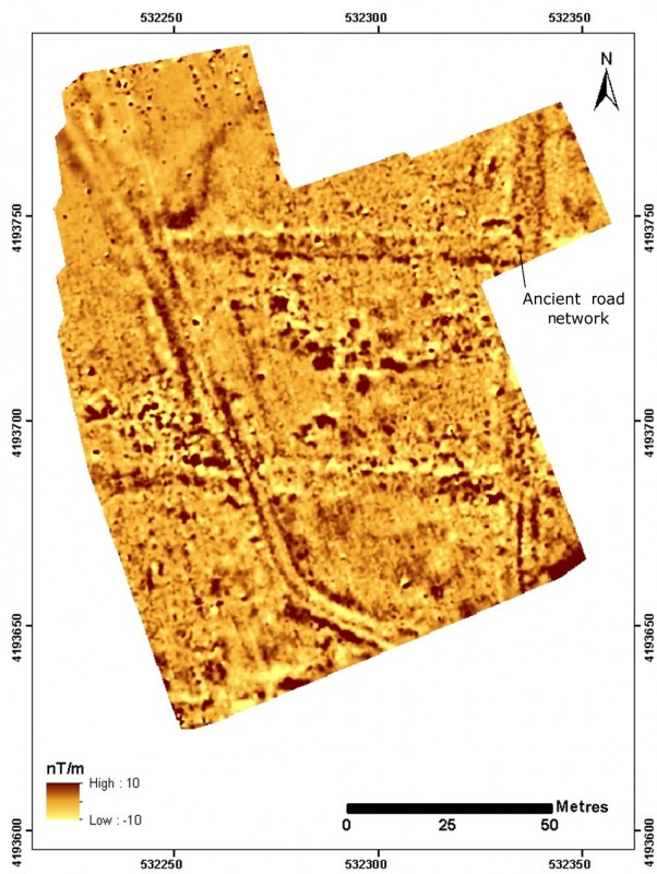
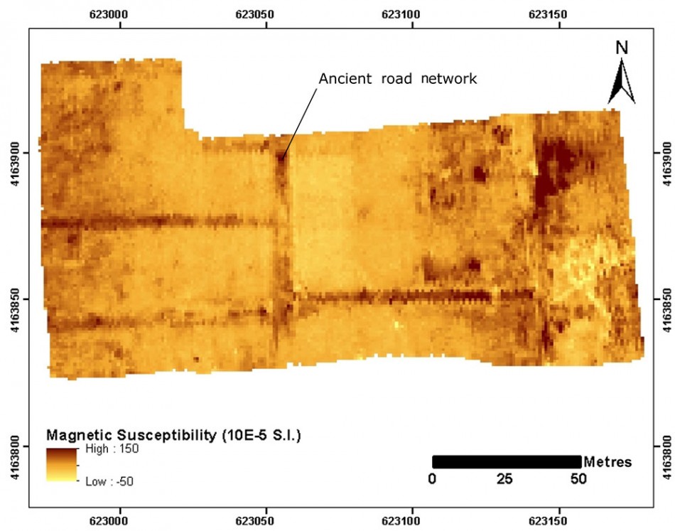
The most important outcome of these surveys is the success of magnetometry and electromagnetic induction techniques for the delineation of sub-surface roads (Figures 3 & 4). These features were most often defined by increased magnetic susceptibility values, depressed conductivity values and elevated vertical-gradient values. These features are almost exclusively orientated north–south or east–west, are regularly spaced and correspond well with associated visible surface infrastructure such as gates. In the case of Elis, these features extend significantly farther from the central agora than expected and so substantially increase the estimated extent of the city.
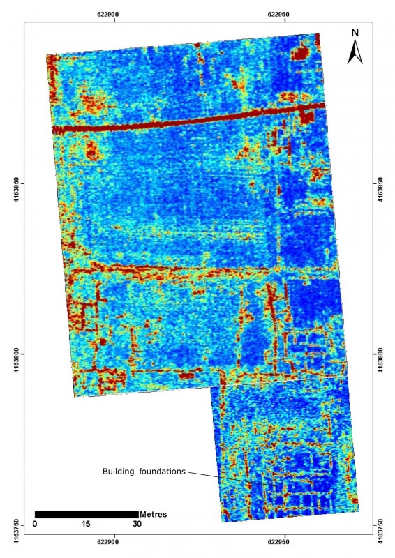
All techniques were able to resolve detail within the city blocks including items of material culture and buried architecture. GPR was particularly successful at mapping details of residential buildings surrounding the agora at Mantinea (Figure 5). Attempts to assess the stratigraphy at this site along selected profiles using Electrical Resistivity Tomography did not show clear features corresponding to the palaeochannel flowing around the city, suggesting that the stratigraphy is complex, with significant anthropogenic disturbance.
Conclusions
The combination of different geophysical methods has contributed to the improved understanding of the archaeological record of Mantinea and Elis. The most significant result is the landscape scale mapping of road networks that have eluded conventional investigations. The results from our geophysical surveys of these classical Greek cities highlight the wider utility of these methods for Mediterranean archaeology.
Acknowledgements
This work was performed in the framework of the AncientCity project (Code: 2013ΣΕ01380048) within the ARISTEIA II Action of the Ministry of Education & Religious Affairs, which is co-financed by Greece and the European Union (European Social Fund) under the NSRF 2007–2013 and the operational programme ‘Education and Lifelong Learning’.
The work in Mantinea has been carried out under the permit of the Hellenic Ministry of Culture (ΥΠΠΟΑ/ΓΔΑΠΚ/ΔΙΚΠΑ/ΤΕΞΕΙΟΔΘ/14801/99 of 03.07.2014) and of Dr A.V. Karapanagiotou who is head of the research programme for the study, excavation and promotion of ancient Mantinea. The Ephoreia of Antiquities of Arkadia provided all the necessary material (topographic plans and excavation plans) from the research that is conducted in the area.
The work in Helis has been carried out under Agreement Contract between the Laboratory of Geophysical-Satellite Remote Sensing & Archaeo-environment and the Ephoreia of Antiquities of Olympias signed on October 9, 2014 and the permit of Dr G. Hadji-Spiliopoulou.
References
- ANDREOU, E & I. ANDREOU. 2007. Ήλις: η πόλη των Ολυµπιακών αγώνων. Athens: Ministry of Culture: Greek Archaeological Receipts Fund.
- DONATI, J & A. SARRIS (in press). Evidence for two planned Greek settlements in the Peloponnese from satellite remote sensing. American Journal of Archaeology 120.
- Fougères, G. 1898. Mantinée et l’Arcadie orientale. Paris: A. Foentemoing.
- SARRIS, A. 1992. Shallow-depth geophysical investigation through the application of magnetic and electric-resistance techniques: an evaluation study of the responses of magnetic and electrical-resistance techniques to archaeogeophysical prospection surveys in Greece and Cyprus. Unpublished PhD dissertation, University of Nebraska-Lincoln.
- TSOKAS, N., A. SARRIS, A. STAMPOLIDIS, G. VARGEMEZIS & L. KOLONAS. 2012 Geophysical exploration in ancient Elis, Πρακτικά 5ου συμποσίου Ελληνικής αρχαιομετρικής εταιρείας Αθήνα: 41–55. Athens: Ekdoseis Papazisi.
- YALOURIS, N.F. 1996. Ancient Elis: cradle of the Olympic Games. Athens: Adam Edition.
- WARNER, R. 1979. A history of my times (Hellenica). London: Penguin.
Authors
* Author for correspondence.
- Ian Moffat*
Laboratory of Geophysical-Satellite Remote Sensing & Archaeo-environment (GeoSat ReSeArch Lab), Institute for Mediterranean Studies, Foundation for Research and Technology-Hellas (F.O.R.T.H.), Nikiforou Foka 130, Rethymnon 74100, Greece (Email: moffat@ims.forth.gr) - Nikos Papadopoulos
Laboratory of Geophysical-Satellite Remote Sensing & Archaeo-environment (GeoSat ReSeArch Lab), Institute for Mediterranean Studies, Foundation for Research and Technology-Hellas (F.O.R.T.H.), Nikiforou Foka 130, Rethymnon 74100, Greece (Email: nikos@ims.forth.gr) - Jamie Donati
Laboratory of Geophysical-Satellite Remote Sensing & Archaeo-environment (GeoSat ReSeArch Lab), Institute for Mediterranean Studies, Foundation for Research and Technology-Hellas (F.O.R.T.H.), Nikiforou Foka 130, Rethymnon 74100, Greece (Email: jcdonati@ims.forth.gr) - Apostolos Sarris
Laboratory of Geophysical-Satellite Remote Sensing & Archaeo-environment (GeoSat ReSeArch Lab), Institute for Mediterranean Studies, Foundation for Research and Technology-Hellas (F.O.R.T.H.), Nikiforou Foka 130, Rethymnon 74100, Greece (Email: asaris@ret.forthnet.gr) - Tuna Kalayci
Laboratory of Geophysical-Satellite Remote Sensing & Archaeo-environment (GeoSat ReSeArch Lab), Institute for Mediterranean Studies, Foundation for Research and Technology-Hellas (F.O.R.T.H.), Nikiforou Foka 130, Rethymnon 74100, Greece (Email: tuna@ims.forth.gr) - Carmen Cuenca-García
Laboratory of Geophysical-Satellite Remote Sensing & Archaeo-environment (GeoSat ReSeArch Lab), Institute for Mediterranean Studies, Foundation for Research and Technology-Hellas (F.O.R.T.H.), Nikiforou Foka 130, Rethymnon 74100, Greece (Email: carmen@ims.forth.gr) - Gianluca Cantoro
Laboratory of Geophysical-Satellite Remote Sensing & Archaeo-environment (GeoSat ReSeArch Lab), Institute for Mediterranean Studies, Foundation for Research and Technology-Hellas (F.O.R.T.H.), Nikiforou Foka 130, Rethymnon 74100, Greece (Email: gianluca.cantoro@gmail.com) - Nasos Argyriou
Laboratory of Geophysical-Satellite Remote Sensing & Archaeo-environment (GeoSat ReSeArch Lab), Institute for Mediterranean Studies, Foundation for Research and Technology-Hellas (F.O.R.T.H.), Nikiforou Foka 130, Rethymnon 74100, Greece (Email: argyriou.nasos@gmail.com) - Kayt Armstrong
Laboratory of Geophysical-Satellite Remote Sensing & Archaeo-environment (GeoSat ReSeArch Lab), Institute for Mediterranean Studies, Foundation for Research and Technology-Hellas (F.O.R.T.H.), Nikiforou Foka 130, Rethymnon 74100, Greece (Email: k.l.armstrong@ims.forth.gr) - Evita Kalogiropoulou
Laboratory of Geophysical-Satellite Remote Sensing & Archaeo-environment (GeoSat ReSeArch Lab), Institute for Mediterranean Studies, Foundation for Research and Technology-Hellas (F.O.R.T.H.), Nikiforou Foka 130, Rethymnon 74100, Greece (Email: evita@ims.forth.gr) - Meropi Manataki
Laboratory of Geophysical-Satellite Remote Sensing & Archaeo-environment (GeoSat ReSeArch Lab), Institute for Mediterranean Studies, Foundation for Research and Technology-Hellas (F.O.R.T.H.), Nikiforou Foka 130, Rethymnon 74100, Greece (Email: mmanataki@gmail.com) - François-Xavier Simon
Laboratory of Geophysical-Satellite Remote Sensing & Archaeo-environment (GeoSat ReSeArch Lab), Institute for Mediterranean Studies, Foundation for Research and Technology-Hellas (F.O.R.T.H.), Nikiforou Foka 130, Rethymnon 74100, Greece (Email: fxsimus@hotmail.com) - Anna-Vasiliki Karapanagiotou
Ephoreia of Antiquities of Arkadia, Hellenic Ministry of Culture, Education and Religion, Kalavryton 211, Tripolis 22100, Greece (Email: akarapanagiotou@culture.gr) - Georgia Hadji-Spiliopoulou
Ephoreia of Antiquities of Olympias, Hellenic Ministry of Culture, Education and Religion, Ankient Olympia 27065, Greece (Email: gchatzi@culture.gr)
 Cite this article