The Pyeonggeo-dong settlements: sustained farming villages of prehistoric and early historic Korea
Site and environment
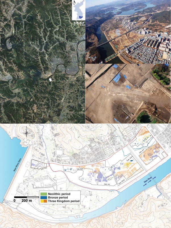
The study of prehistoric settlements on alluvial flatlands provides crucial information on early agricultural developments around the world (Smith 1992; Zeder & Smith 2009). An exemplary case comes from the site of Pyeonggeo-dong in south-central Korea, revealing over 1600 features from the Upper Palaeolithic through to historical periods. Salvage archaeological projects (2006–2010) have recorded dwelling structures, burials, altars and sequences of agricultural fields across an area of 46.7ha (Figure 1).
The Nam River, a tributary of the Nakdong, has cut steep slopes on one side and formed alluvial lands on the other. The resulting landscape is well connected and fertile. Along a lower reach of the Nam River, archaeological features are spread across an alluvial point bar, revealing a complex sequence of occupation and abandonment attuned to cycles of flooding.
Succession of farming villages
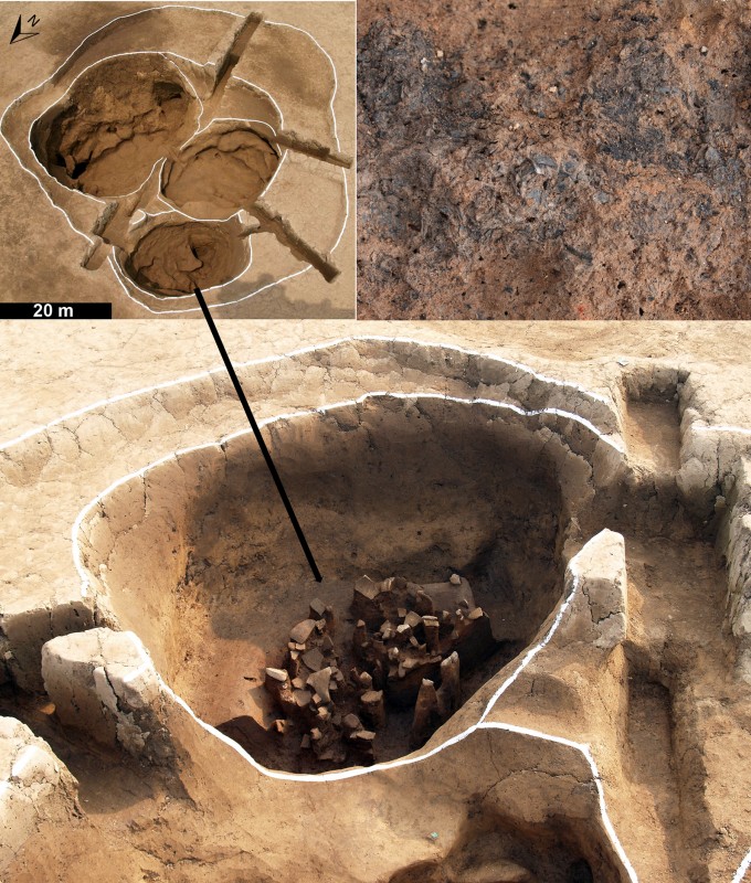
The earliest settlements at Pyeonggeo-dong date to the Middle–Late Neolithic (or Chulmun) period; a series of AMS dates indicate activity between 5240 and 4600 cal BP (GDICH 2011, 2012). Neolithic structures, including pit houses, open-air hearths, ditches, pits and kilns, were located on higher ground and natural levees (Figure 2).
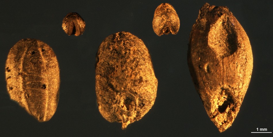
Acorns (Quercus sp.), cached in several pits, and other edible annual wild grasses and fruits suggest the exploitation of forest resources and areas of disturbed ground near the settlements (G.-A. Lee 2011, 2012). Neolithic inhabitants also cultivated domesticated millets (foxtail and broomcorn), as indicated by their ubiquitous and abundant presence in archaeological features of all types (Figure 3). The occurrence of two types of Asian legumes (soybean and azuki) may indicate human management by 5100–4600 cal BP, which eventually led to domestication (Lee et al. 2011). Various millet-tribe (Paniceae) grasses reflect weeds commonly grown in dry farming fields of millet and legume.
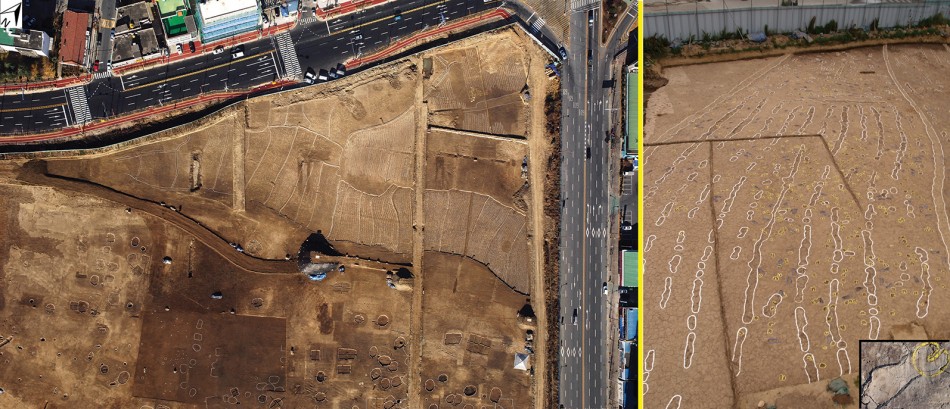
Clear evidence of multiple cropping comes from the Early Bronze (Mumun) period (2400–1900 cal BP). In addition to the crops already cultivated during the Neolithic, rice, barley and wheat were also farmed. Extensive areas of dry farming were located along the slopes of levees, and wet rice paddy fields were constructed in the backwater swamps (Figure 4). AMS dating of charcoal from the dry fields (UCI 68839, 2815±15 BP) and rice paddies (UCI 68844, 2930±15 BP; UCI 68845, 2915±15 BP) indicates Early Bronze Age use , while samples of wheat (UCI 67222, 2585±20 BP) and charcoal (UCI 68838, 2750±15 BP; KRK-64, 2810±30 BP) from the dry fields point to the Late Bronze Age (2900–2400 cal BP)(Cullen 2011).
During the Three Kingdom period (c. AD 300–668), agricultural fields had been further expanded to cover the backwater swamp areas as well as an ancient river bed, which was filled with fluvial deposits following the Bronze period. Micromorphological analysis of soils demonstrates a clear sequence of repeated irrigation and intensive soil perturbation by the early Three Kingdom period (H. Lee 2012). An increase in grass pollen combined with an overall decline in pollen quantities, especially of arboreal species, implies forest clearance from the Late Bronze Age and, more significantly, during the Three Kingdom period (Chung et al. 2011). Rice production increased with the use of iron tools and draft cattle for ploughing irrigated fields (Figure 4). It is unclear whether a lack of archaeological features post-dating to the Late Bronze Age prior to the Three Kingdom period is due to a cultural hiatus or a post-depositional disturbance. Both the expansion of agricultural fields and the increased number of residential features reflect, however, an influx of people to the region during the Three Kingdom period.
Discussion
The Pyeonggeo-dong site reflects the long-term development of an agricultural landscape from 5100 cal BP. Our ongoing macro- and micro-botanical analyses have revealed the cultivation of millet and the possible management of indigenous plants by the Middle Neolithic period, followed by intensive multi-cropping agriculture from the Bronze Age onwards. Geomorphological survey also suggests the preference of early farmers for alluvial land. Our evidence for the extensive construction and continuous modification of fields provides a solid database on which to model long-term knowledge transmission and cultural niche construction. We can trace socio-economic processes revealing not only the technology of farming, but also the organisation of communal labour. Across time, the stewardship of valuable alluvial agricultural land attracted more people to the area resulting in the complexity of the archaeological remains recovered at Pyeonggeo-dong. Such a well-preserved agricultural landscape is rare, but there are parallels with some European Neolithic examples (e.g. Bogaard 2004) and with traditionally irrigated fields in Bali, Indonesia (Lansing & Fox 2011). Currently, we are awaiting further AMS dates on charred crop remains in order to reconstruct a finer chronology of agricultural development. We also intend to apply agent-based modelling to assess how the fields were constructed and maintained over multiple generations.
Acknowledgements
We express our thanks to all the participants of the fieldwork and laboratory work at Pyeonggeo-dong. This work was supported by the Laboratory Program for Korean Studies through the Ministry of Education of the Republic of Korea and the Korean Studies Promotion Service of the Academy of Korean Studies (AKS-2015-Lab-2250001).
References
- BOGGARD, A. 2004. Neolithic farming in Central Europe. London: Routledge
- CHUNG, C., J. KIM & H. LIM. 2011. Radiocarbon dating and analysis of paleo-soils at Pyeonggeodong 3-1, in Gyeongnam Development Institute-Center of History and Culture (GDICH) (ed.) Excavation of Pyeonggeo-dong site locality 3-1: 199–222. Haman: GDI.
- CULLEN, B.J. 2011. Direct AMS 14C dating of plant domesticates from Pyeonggeodong, Korea (project UO-517 & 519), in GDICH (ed.) Excavation of Pyeonggeo-dong site locality 4-1: 372–85. Haman: GDI.
- GDICH (ed.). 2011. The excavation of Pyeonggeo-dong site locality 3-1. Haman: GDI.
- – 2012. The excavation of Pyeonggeo-dong site locality 4-1. Haman: GDI.
- LANSING, J. S. & K. M. FOX. 2011. Niche construction on Bali: the gods of the countryside. Philosophical Transactions of the Royal Society B Biological Sciences 366: 927–34.
- LEE, G.-A. 2011. Plant remains from the Pyeonggeo-dong site, locality 3-1, in GDICH (ed.) Excavation of Pyeonggeo-dong site locality 3-1: 303–19. Haman: GDI.
- – 2012. Plant remains from the Pyeonggeo-dong site, locality 4-1, in GDICH (ed.) Excavation of Pyeonggeo-dong site locality 4-1: 328–43. Haman: GDI.
- LEE, G.-A., H.-P. YOON, M.-J. KO & C.-Y. KIM. 2011. Plant use in the Nam River Valley during the Neolithic period. Yeongnam Archaeological Review 56: 5–42.
- LEE, H. 2012. A geoarchaeological study on early paddy rice cultivation. Journal of the Korean Archaeological Society 82: 84–113.
- SMITH, B. (ed.). 1992. Rivers of change: essays on early agriculture in eastern North America. Tuscaloosa: The University of Alabama Press.
- ZEDER, M. & B. SMITH. 2009. A conversation on agricultural origins: talking past each other in a crowded room. Current Anthropology 50: 681–91. http://dx.doi.org/10.1086/605553
Authors
* Author for correspondence.
- Hopil Yun
Jungbu Institute for Archaeology, 129 Jungbudae-ro, Paldal-gu, Suwon, Gyeonggi 16249, South Korea (Email: hpyoon203@empas.com) - Min-Jung Ko
Center of History & Culture, Gyeongnam Development Institute, 34 Sambang-ro, Gunbuk-myeon, Haman-gun, South Gyeongsam 52068, South Korea (Email: mting@hanmail.net) - Gyoung-Ah Lee*
Anthropology, University of Oregon, 1321 Kincaid Street, Eugene, OR 97403-1218, USA (Email: galee@uoregon.edu)
 Cite this article