ALISON DEEGAN & GLENN FOARD Mapping ancient landscapes in Northamptonshire. viii+172 pages, 102 b&w & colour illustrations, 12 tables. 2007. Swindon: English Heritage; 987-1-905624-42-3 paperback (copy available as print-on-demand from ehsales@gillards.com or download from http://www.english-heritage.org.uk/server/show/ConWebDoc.14150)
JAN HARDING & FRANCES HEALY The Raunds Area Project: a Neolithic and Bronze Age landscape in Northamptonshire. xviii+324 pages, 160 b&w & colour illustrations, 14 tables. 2007. Swindon: English Heritage; 978-1-873592-99-1; paperback (copy available as print-on-demand from ehsales@gillards.com or download from http://www.english-heritage.org.uk/server/show/ConWebDoc.13537)
In archaeological terms, the English midlands county of Northamptonshire is truly blessed. Although lacking the upstanding monuments and nineteenth-century antiquarian tradition of the southern Pennine counties, during the mid twentieth-century the county received the full attention of the Royal Commission on Historical Monuments for England, with the publication of six major volumes between 1975 and 1982. The RCHME project also published, in 1980, an A3 volume of distribution maps, inventively presented as loose transparent overlays. Meanwhile the County Council initiated one of the better funded and most innovative of the fledgling Sites and Monuments Records. Furthermore, a substantial programme of rescue excavations by both professionals and active amateurs, especially in the mid and upper Nene valley, was producing important results, and the Northampton Development Corporation funded most generously the excavation and publication of sites ranging in date from the prehistoric to the medieval periods within and around the expanding city of Northampton itself.
Against this background, English Heritage mounted a groundbreaking survey and excavation project in a lesser-known location along the reaches of the River Nene. This was the Raunds Area Project, conducted in the field between 1985 and 1993. The overall aim was to investigate the archaeology of an intact area of historic landscape, in a zone which was due to be transformed by gravel extraction, road construction and residential building. Near the end of this ambitious fieldwork project, the wide-ranging programme of archaeological air survey, which had been undertaken by Northamptonshire County Council, and in effect master-minded by Glenn Foard, was one of the earlier county initiatives to be taken under the umbrella of the English Heritage National Mapping Programme (NMP), which was founded in 1992.
The aim of the NMP is to enhance understanding of past human settlement, by providing primary information and syntheses for all archaeological sites and landscapes (visible on air photographs) from the Neolithic period to the twentieth century. Most of the existing air photographs were mapped digitally during the 1990s and linked to the Sites and Monuments Record by a GIS system. A total of 20 000 photographs relate to over 14 000 individual archaeological sites. Most of the sites are cropmarks, but some soilmark and earthwork sites are also represented. The results of the entire project are now summarised in the beautifully illustrated volume Mapping ancient landscapes in Northamptonshire. The Raunds Area Project, on the other hand, was undertaken by English Heritage in partnership with the (then) Northamptonshire Archaeological Unit; it has also gathered in the results of some adjacent field projects undertaken by Oxford Archaeology. The main project themes that emerged were the development of early prehistoric monuments, agricultural expansion in the Iron Age and Roman periods and the formation of Saxon villages. Analysis of the excavation results relating to Iron Age and later sites is still ongoing, but an exciting account for the earlier periods is now available in the first project volume A Neolithic and Bronze Age landscape in Northamptonshire.
The air photography volume begins and ends with discussions relating to the biases in the distribution of air cover caused by the variation in soils, geology and past and present land use, and careful assessment of the methodologies employed. The meat of the book is a series of six period chapters ranging in date from the Neolithic to modern military installations, but the most detailed treatment applies to the prehistoric and Roman periods. The chapter on Neolithic and Bronze Age sites (Chapter 4) uses data from excavated sites to provide additional chronological data, and especially the results from the Raunds project. The pages of site plans by type are very useful and illuminating, but the maps could have been related to the text better by the addition of some key site names. The round barrows and ring ditches do not seem to cluster to form cemetery groupings in the river valleys, and this is in contrast to some areas in southern England. Further contrast is provided by the paucity of classic henge or cursus monuments, and it would be interesting to compare this situation in detail with the pattern of monument concentrations that is known for the west midlands region. Although the project admittedly largely missed the boat in relation to recording medieval ridge and furrow cultivation or twentieth-century military remains (Chapters 8 and 9), the summary of achievement in relation to sites of Iron Age and Roman date is outstanding (Chapter 6). In addition to recording and classifying enclosures relating to occupation and pastoral use, it has been possible to map whole areas of agricultural landscape, sub-divided by ditch systems and/or pit alignments, both along the valley floors and in some higher zones, and these are clearly illustrated in colour. The accompanying distribution maps are now enhanced by the addition of the names of key sites described in the text. A total of nearly 5000 enclosures of possible Iron Age or Roman date have been plotted, and there is also air photographic evidence relating to 34 of the total of 93 Roman villas known within the county. The Saxon and medieval sections (Chapters 7 and 8) contain impressive illustrations which map crop or soilmarks against earthwork evidence within deserted or shrunken villages and hamlets, and the consideration of the striking soilmark signature for charcoal burning associated with the iron industry during these periods is both stunning and of national importance.
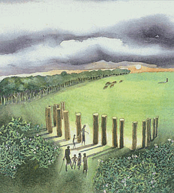
The prehistoric Raunds Area Project volume is a fine example of a totally integrated excavation report, which incorporates all the key results from the large team of specialists involved within a single carefully paced narrative. The book will be accompanied by a second volume containing all the specialist reports and detailed excavation accounts; however, this volume was sadly not available at the time of writing. The results are particularly remarkable in that they describe a prehistoric monumental landscape which had been almost totally obscured by a thick layer of early medieval alluvium on the floor of the Nene valley. Activity in the Mesolithic and earliest Neolithic periods at a river confluence led to the construction, soon after 4000 cal BC, of the first major monument (Long Mound) in an area of pasture which had been grazed by livestock. This was a communal monument constructed in segments which may have been built by different social groups. It was followed by three more, mainly linear, monuments, including a Long Barrow with a small limestone burial chamber. Waterlogged environmental data showed that this was built in a grazed clearing in recently cleared woodland. During the later Neolithic period the sites were less frequented and there was some woodland regeneration; activity may have been more focused on a nearby probable henge monument which lay outside the study area. However, from c. 2200 cal BC monument building increased in pace and, from a total of over 20 round barrows, nine were excavated. Almost all of these contained burials, including the intriguing burial of a man in Barrow 1, buried with many exotic objects and covered by a cairn of limestone and then a layer of about 200 cattle skulls. As the cremation rite became more common through time, many of the barrows were enlarged and reused down to c. 1000 cal BC. Finally, two systems of paddocks were evidence for a pastoral landscape, developed over and around the barrows. The results of the carefully considered programme of radiocarbon dating are outstanding.
The Raunds site narratives can be checked against the full provision of plans and section drawings, but unfortunately not quite enough information is provided for the finds. The grave goods are shown on the burial plans, which is useful, but cross-sections of the objects are not included. Without resort to the supplementary volume it is not possible to rapidly assess raw materials and typological aspects of the finds; and this could easily have been provided in an extra page or two of text. Both books use a system of 'panels' to provide more detailed information on selected topics, and this works well. Less happy is the incidence of typographic errors in the air photography volume, and indeed a discontinuity in pagination, and some missing pages, in the copy supplied for review.
The text of the air photography book is dense and tightly written. Maybe readers will mainly dip into it as a reference tool, but much can be gained by 'reading' the excellent sequence of illustrations. In comparison the Raunds volume is an easy read, which should be enjoyed by all those interested in Neolithic and Bronze Age Britain. The burial sections encompass a microcosm of developing funerary customs and, with its thoughtful discussion of the entire dataset of burials from a wide area of the east midlands, provides a welcome contrast with the picture usually derived from Wessex. English Heritage has demonstrated through these volumes the wealth of detail that exists relating to archaeological landscapes in middle England, and both books are highly recommended.