Review Article
Seeing under the sediments: acculturation in the fifth
and fourth millennia cal BC in the Netherlands
Frances Healy
School of History and Archaeology, Cardiff University
Humanities Building, Colum Drive, Cardiff CF10 3EU, UK
(Email: HealyFM@Cardiff.ac.uk)
Books Reviewed
J.H.M. PEETERS. Hoge Vaart-A27 in context: towards a model of Mesolithic-Neolithic land use dynamics as a framework for archaeological heritage management. 342 pages, 183 illustrations, 35 tables, CD-ROM. 2007. Amersfoort: Rijksdienst voor Archeologie, Cultuurlandschap en Monumenten; 978-90-5799-092-2 paperback €20.
Available at http://dare.uva.nl/en/record/211007

LEENDERT P. LOUWE KOOIJMANS & PETER F.B. JONGSTE (ed.). Schipluiden: a Neolithic settlement on the Dutch North Sea coast c. 3500 cal BC (Analecta Praehistorica Leidensia 37/38). x+516 pages, 309 b&w & colour illustrations, 118 tables. 2006. Leiden: Faculty of Archaeology, Leiden University; 978-90-73368-21-7 paperback €90.
These two volumes from the Netherlands complement each other chronologically and geographically. Peeters' work centres on the sixth to fifth millennia cal BC, taking the detailed analysis of a repeatedly occupied sand ridge (Hoge Vaart-A27) as a springboard for the development of a framework for the management of Mesolithic and Neolithic landscapes, specifically buried landscapes in the province of Flevoland, where the Early Neolithic Swifterbant element is particularly marked, not least at the type site. To the south, in Delfland, Louwe Kooijimans' and Jongste's volume is a set-piece report on the almost total excavation of a dune at Schipluiden occupied in the second and third quarters of the fourth millennium cal BC by a Middle Neolithic Hazendonk population.
Hoge Vaart-A27 and Flevoland
Peeters challenges the often site-centred practices of curatorial archaeology with the results of much thinking - the book being his 2007 University of Amsterdam doctoral dissertation - about, inter alia, how to deal with buried low-density, low-resolution, low-visibility archaeology; the need to judge the archaeological worth of an area by the quality as well as the quantity of its information; the importance of genuinely blank areas; the abiding significance of repeatedly used locations; the need to factor uncertainty into heritage management; and, above all, the need to consider the extractive, domestic, transient and interactive activities of hunter-gatherers and early farmers within a continuous, four-dimensional landscape, of which topographic, hydrological, vegetational and other changes are integral parts.
His response to these challenges is founded on statistical modelling, employing a variety of techniques within a GIS environment. At the level of the Hoge Vaart-A27 excavation, he uses the structure of an isolated, demonstrably single-event, artefact concentration to interpret a much larger adjacent concentration which is the result, not of a more substantial occupation, but of repeated occupations of a character similar to that of the isolated cluster. At the level of the province, he uses palaeolandscape evidence to model the probability that traces of different types of human behaviour will occur in particular geographical areas. This inspires some confidence because it is primarily based on available resources and accessibility at any given time in a rapidly changing landscape, rather than on the haphazard record of previous archaeological discoveries. These signatures are mapped at 500-year intervals. The incorporation of erosion models indicates potential levels of survival as well as original presence.
There is much food for thought here, sometimes made less digestible than necessary by a rather bureaucratic, heritage-management style. When it comes to chronology, statistical modelling falls short of the standards achieved for landscape studies. The exercise is conducted in years BP, so that the time-slices chosen for various analyses are of different lengths, according to where they fall on the calibration curve. There are only occasional nods to calibration, and analysis of the dates from Hoge Vaart-A27 seems to be based on their central measurements rather than on their probability distributions. There is a strong case here for calibration and modelling, also for considering the extent to which individual samples might have been contemporary with their contexts or older than them and for supplying fuller sample identifications which the reader could then use to reach an independent judgement.
Schipluiden
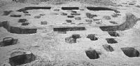
Radiocarbon dates are handled far more professionally in the Schipluiden report, although, once again, the possibility that some might be termini post quos is not entertained and sample identifications are minimal. Statistical analysis here impressively extracts four repeatedly used house sites from a forest of postholes. Much of the value of the site lies in the combination of a virtually complete settlement plan with the preservation and stratification of a large and rich assemblage of artefacts and food remains in the surrounding reedswamp deposits which accumulated in the course of 200-300 years of occupation. The evidence is superbly presented by the editors and a large team of contributors, enhanced by clear and vivid illustrations, many of them in colour. An overarching achievement is the level of reconstruction of the scale and organisation of the settlement. The plan and the distributions of cultural material are persuasively worked into a picture of four simultaneously occupied houses belonging to a single social unit, bordered (possibly surrounded) by a single fence, which was replaced progressively higher up the dune side as the reedswamp encroached. The subsistence and maintenance activities, on and away from the dune, of a population of about 25 people are convincingly reconstructed and extrapolated to a wider Delfland microregion. External contacts, mainly with Middle Neolithic Michelsberg areas to the south and east, were confined to the acquisition of relatively small amounts of non-local raw materials. It is grounds for congratulation to all concerned that the comprehensive and scholarly Schipluiden report was published only three years after the completion of fieldwork. The final synthetic chapter is Louwe Kooijimans at his best: masterly, lucid, vastly knowledgeable, and situating the local evidence in its European context.
Dutch practice, in archaeology and in prehistory
Seen from the other side of the North Sea, these works convey a mixture of the familiar and the very different. On the methodological front, the way in which boreholes are routinely used as a means of prospection in buried landscapes is unmatched in British wetland areas, and, if applied there, could transform their archaeology. Peeters' landscape reconstruction incorporated stratigraphic results from some 19 000 cores (most of them taken for geological purposes). The evaluation of Hoge Vaart-A27 was accomplished by 1300 boreholes taken on a 2 x 2m grid; while Schipluiden was discovered by deep boring carried out for archaeological prospection in advance of construction and subsequently evaluated by 26 further borings.
In prehistory, the well-established gradual uptake of Neolithic practices by Swifterbant populations contrasts with their relatively abrupt appearance in Britain. This is nothing new. It is noteworthy, however, that later on, in the mid fourth millennium cal BC, there are equally strong distinctions between the subsistence bases of the population of Schipluiden and those of southern England. At Schipluiden, the quality and range of the evidence makes it possible to estimate that animal protein came from domestic sources, wild terrestrial sources and aquatic sources in the approximate ratio 2:1:3. This is a different world from that of contemporary English sites, where game is vestigial in animal bone assemblages and fish invisible, while human stable isotope values, depending on their interpretation, indicate either no consumption of aquatic protein or a much lower consumption than at Schipluiden. These very different practices and beliefs with regard to food animals are thrown into further relief by the lack of any trace of dairying in the kill pattern at Schipluiden, in contrast to a growing body of evidence for its practice at this time in southern England. As Louwe Kooijimans emphasises, the broad spectrum economy of Schipluiden and other Hazendonk sites reflects a continuation of the gradual neolithicisation of Swifterbant times. The long-lasting, fenced settlement is equally unfamiliar on English soil. Despite collateral relationships between artefact inventories, these two contemporary Neolithics had very different roots and histories.