Book Review

SARAH H. PARCAK. Satellite remote sensing for archaeology. xx+286 pages, 141 illustrations, 11 tables. 2009. Abingdon & New York: Routledge; 978-0-415-44878-9 paperback $44.95 & £24.99. Companion website at: http://www.routledge.com/textbooks/9780415448789.
Review by Daniel Donoghue
Department of Geography, Durham University, UK
(Email: danny.donoghue@durham.ac.uk)
This is one of the first books dedicated specifically to the use of satellite-based remote sensing for archaeological study. It follows on from Irwin Scollar's seminal 1990 Cambridge University Press text Archaeological prospection and remote sensing that provided the archaeological community with a highly technical and hugely detailed overview of imaging and geophysical prospection techniques. Scollar's book focuses on airborne imagery and ground-based geophysical prospection techniques; this was the era before the launch of the first US commercially available high resolution satellite imagery in 1999. Although Russian imagery was available in the early 1990s, little use was made of former spy satellite imagery for archaeology until the first declassification of data from the American Keyhole (often termed CORONA) missions in 1995. These images first acquired in the 1960s and 1970s are used extensively in many parts of the world including Egypt where Sarah Parcak herself helped pioneer new approaches for mapping ancient settlements over large areas.
Parcak's book, therefore, explores much new ground for the archaeological and heritage management community; until now, no one has attempted to compare and contrast systematically how the satellite imagery and terrain models now available can be applied to archaeological problems. This book is published at an interesting time when landscape archaeology is expanding intellectual horizons, knitting together physical and cultural phenomena and posing new questions about economic, environmental and cultural aspects of landscape occupation. While field survey underpins the landscape archaeologist's approach, satellite remote sensing offers new, exciting and complementary mapping techniques that allow study to range across wide geographical areas.
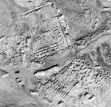
In Chapter 2 the reader immediately gets a sense of the rapidly expanding literature on remote sensing for archaeology and the excellent bibliography, although not exhaustive, provides a useful starting point. The book aims to provide information and practical examples to encourage the use of remote sensing in archaeological investigation. As the author states, the chapter dealing with image types needs to be read in the context of a non-technical summary of typical data sets. The volume indeed provides a brief overview of the most widely used data sets but it is not a definitive reference source on technical details; information on CORONA could have contained more detail on global coverage and on the range of factors that affect image quality; reference to Landsat and SPOT often confuses the names of the satellites and the sensors carried; the terms mid infrared is used instead of shortwave infrared when referring to Landsat TM/ETM+ and SPOT HRV sensors. It would have been nice to see high quality illustrations of CORONA, Landsat, SPOT and ASTER. The book contains only two CORONA images on pages 59 and 97 and only one is of sufficient scale to allow archaeology to be seen clearly. Indeed the caption scales do not match the images as printed throughout the book. The lack of colour plates makes it difficult to illustrate and do justice to the value of multispectral imagery.
The chapter on 'Landscape approaches and project design' is an interesting attempt to review the applicability of different data sets in different landscape types (rainforest, desert, alluvium etc.) and feature types (settlement, routes, agriculture etc.). The discussion of features is innovative as it combines ideas familiar to air photography interpreters with typical archaeological typologies. The chapter ends with the key question 'How much can satellites detect?' It is precisely this sort of question that students need to think about when applying remote sensing in their own work. The case studies chapter draws together contrasting studies ranging from prospection to settlement analysis in Guatemala, Cambodia, China, Oman, Syria and Egypt. These précis a number of important papers that have transformed our understanding of ancient cultural landscapes. Sophisticated mapping of Angkor in Cambodia using space shuttle and airborne RADAR have facilitated new interpretation of the scale and pattern of settlement and its relationship with the well-known water management features. In Syria the combination of image interpretation and detailed field survey has proved invaluable for addressing longstanding questions of settlement distribution and continuity from the Early Bronze Age to recent times. The book focuses more on technical methodology than interpretation and analysis. Here it is overly reliant on Google Earth and NASA World Wind as sources of illustrative material rather than sourcing published imagery. By contrast, the author's own images are good and used effectively to illustrate how field survey and remote sensing can complement each other. Chapter 7, 'Remote sensing and survey', is well illustrated and touches on important practical matters of locating oneself accurately on the ground, establishing an effective field recording strategy, providing reliable dating evidence and integrating field survey and imagery within a GIS.
In recent years, fine resolution digital satellite imagery has become widely available at a scale that can be used as an alternative to aerial photography. Added to the availability of new and historic imagery, is the ability of the internet to make these data easily accessible to the academic and wider public communities. Parcak includes an interesting chapter that explores the pros and cons of publishing archaeological imagery which raises many questions concerning internet-based image viewers such as Google Earth or World Wind and how scholars will access, combine and disseminate images, maps and other spatial data in future. Parcak's book is sometimes guilty of blurring the boundaries of airborne and satellite remote sensing and this is also a feature of internet-based image viewers; it's not always easy to know whether you are looking at an aerial photograph or a satellite image, and does it matter? There is a need to think carefully about mechanisms for publishing imagery and image interpretations for archaeology and heritage management so that the academic benefits of access to original data can be balanced with the ethical dilemma of misuse from a heritage conservation and management perspective. The final two chapters of this book provide a useful starting point in such a debate.
Despite its limitations this book provides new material on satellite remote sensing that any student of archaeology should be aware of. The world of satellite imaging moves so rapidly that the author can be forgiven for information that is already outdated. The case studies certainly provide a useful introduction to a wide range of important research papers. Overall the text is a good introduction for undergraduate students of archaeology, anthropology and geography. Postgraduate students will need to use it alongside more specialist literature. Nevertheless, it is written in a lively style that makes a highly technical subject accessible to a general audience.